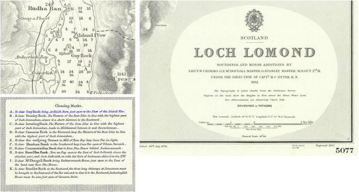
The 1861 Admiralty Chart 5077 of the area is shown below. Sailors used Elanvow as a guide to clear a dangerous submerged rock called Guy Rock. (See Clearing Marks reference below.)
"A. To clear Guy Rock bring Ardleish Barn just open to the East of Island Vow".
"A. To clear Guy Rock bring Ardleish Barn just open to the East of Island Vow".
So the case for Vow as "Sunken Rock" or "Breaker Rock" ...or any other variant of warning, foreboding, submerged rock ... seems strong and credible. We continue to research the point. Surely, the island was later referred to by locals as The island of the Store ... and, perhaps, even the Island of the Cow ... but we submit that the island was named earlier for the submerged rock hazard (now Guy Rock). As mariners made their way north, this lone island would give warning and provide a reference for safe passage around the sunken rock and would be worthy of the name "The Island of the Sunken Rock".
We suggest that it is and always has been (since "vow" was first written) "The Island of the Sunken Rock" (Eilean-a-Bhogha). At later points in time, it has also been known as The New Island (Eilean-Ùr) and The Island of the Store (Eilean-a-Bhùth).
We suggest that it is and always has been (since "vow" was first written) "The Island of the Sunken Rock" (Eilean-a-Bhogha). At later points in time, it has also been known as The New Island (Eilean-Ùr) and The Island of the Store (Eilean-a-Bhùth).
1861 Admiralty Chart 5077